Kia ora, ko Francois tōku ingoa! I am a postdoctoral fellow between the University of Waikato and Earth Sciences New Zealand (ex NIWA), I am currently based in Wellington, New Zealand. Within the Tau Ki Ākau - Ridge to Reef - research project, my research investigates the consequences of extreme events for coastal ecosystems and in a multi-stressor context, such as changes in water clarity, coastal darkening, marine darkwaves, and increasing marine heatwaves. I am especially interested in the consequences of marine darkwaves, and finding out ways we can prevent them. To pursue it, I combine satellite remote sensing, optical modelling of underwater light and physiology. Broadly speaking, I am interested in bridging theoretical and applied ecology. Previously, I was a PhD Student at the University of Canterbury (UC) in Christchurch, New Zealand, and did my Bachelor and Masters at Aix-Marseille University, France.
Beyond academic research, I am interested in making scientific knowledge useful for people and communities, alongside other Knowledge Systems.
Publications and reports
Marine darkwave as an event-based framework to assess unusual periods of reduced underwater light availability Communications Earth & Environment
François Thoral , Matthew H Pinkerton, Shinae Montie, Mads S Thomsen, Christopher N Battershill, Karen Filbee-Dexter, Mark Gall, Robert J Miller, Shane Orchard, Daniel C Reed, Leigh W Tait, Spencer DS Virgin, Thomas Wernberg, John Zeldis, David R Schiel.
Episodic reductions in underwater light can be a key driver of marine ecosystem degradation. Yet a consistent event-based framework describing the frequency, duration and intensity of substantial but short-term reductions in underwater light does not exist. Here, we proposed marine darkwaves as a framework for quantifying these episodic reductions of underwater light at specific depths which aligns with definitions of other episodic and extreme events. The framework was applied to long-term in situ time series of underwater irradiance from California, USA (16 years, 6.3 metres) and New Zealand (10 years, at 7 and 20 metres). We showed evidence of several intense marine darkwaves across these sites, with durations up to 64 days, cumulative light deficits reaching −105.6 mol photon·m−2, and up to almost 100% light loss versus climatology. We extended the framework to satellite-derived seabed irradiance data across New Zealand’s East Cape region (2002–2023), using a set of 10th percentile threshold and a minimum duration of 5 days. This revealed 25 to 80 spatially varying seabed events, and event durations of 5 to 15 days. Importantly, the framework enables local to continental-scale comparisons of the patterns and ecological consequences of episodic light reduction in marine ecosystems.
January 2026
Multi-model ensemble forecasts of sea surface temperatures and marine heatwaves for Aotearoa New Zealand Frontiers in Marine Science
Rafael Santana, Neelesh Rampal, Nicolas Fauchereau, Hamish Lewis, François Thoral , Peter B Gibson, Niall Broekhuizen
Marine heatwaves (MHWs) adversely impact Aotearoa New Zealand’s marine ecosystems and pose challenges for resource management. In this study, we evaluate forecast skill of monthly MHWs and sea surface temperature (SST) anomalies using a multi-model ensemble (MME) comprised of nine general circulation models and 206 members with a focus on Aotearoa New Zealand for the first time. Over the hindcast period (1993–2016), the MME outperforms individual models in forecasting SST anomalies around Aotearoa New Zealand, based on its higher anomaly correlation coefficient (ACC) and lower root mean square error (RMSE). The forecast skill of the MME varies seasonally, and is highest for forecasts initialized between June and September and lowest from October to December. Forecasts generally outperform persistence across all months and lead times, except at certain lead times between September and December. The background climate state also influences the MME skill, with higher accuracy during El Niño for forecasts initialized from December to February and during La Niña for certain lead times from March to August. Skill improves in spring under neutral (normal) conditions. We also evaluate the MME’s skill in predicting MHW events using a probabilistic framework. The MME retains skill up to two months along Aotearoa New Zealand’s western coast and upper east North Island but has negligible skill at four- and five-month lead times. Overall, these findings highlight that MHW and SST can be forecasted with reliability, especially at one and two months of lead time with important implications for marine resource management.
Leigh W. Tait, Rose Pearson, Andra Whiteside, François Thoral , Steph Mangan
Giant kelp is one of the largest and fastest growing seaweeds in the world, it provides food and habitat for marine life, and engineers the physical environment around it. It is also a managed fishery in Aotearoa New Zealand. Because of its key role in supporting marine fisheries (particularly pāua, kina, kōura, and several key finfish) and the increasing interest in the commercial harvesting of seaweeds, we need a greater understanding of the current distribution of giant kelp. Here we utilise satellite remote sensing to track the distribution of giant kelp across Aotearoa New Zealand over the last decade. Satellites provide a passive and free tool for monitoring the expanse of surface canopies. This is particularly relevant as kelp forest ecosystems are impacted by extreme events such as marine heatwaves and cyclones. We show that satellite remote sensing of giant kelp can be used effectively to track the status and health of giant kelp which provides a powerful tool for identifying the drivers of change in kelp beds. By looking for relationships between key environmental parameters and kelp forest coverage, we found that national level declines in giant kelp beds are highly associated with periods of warmer oceanic conditions. We provide a summary of regional trends of giant kelp coverage and assess the environmental factors that drive variation. This work is accompanied by a web interface that allows managers and stakeholders to view and assess satellite products and the outputs of our kelp cover estimates.
October 2025
Marine science in Aotearoa New Zealand: a community-sourced over-the-horizon perspective New Zealand Science Review
François Thoral , Laura Kaikkonen, Gabby O'Connor, Pete Russel, Chalrine Dalinghaus, Neelesh Rampal, Laila Patchett, Billie Robertson, Baxter Berdinner, Isla Robertson, Eleanor Chaos, Preston Maluafiti, Will McCoy, Brendan Flack, Louis Scherer, Joe O'Callaghan, Kath Large, Craig Stevens
As natural and social environments continue to change, socioeconomic systems need to anticipate change and adequately react. Science, in general, is a critical component of the anticipation. Marine science, as a scientific research field that seeks to understand a significant proportion of our planet, is no exception. Here we provide an outlook on the future of marine science - how it is perceived by society and done by people – in Aotearoa New Zealand. This was informed by a group of early, mid, and late career marine scientists, industry representatives, Indigenous coastal guardians, high school students and ocean users who sought to envision what marine science could look like in 2050. Based on a workshop session, we provide ten recommendations to stakeholders, managers, funders, and scientists to bring marine science closer to a trajectory aligned with society’s expectations and needs. Marine science needs to adapt practices to respond to an increasing demand for providing both expert knowledge and public information, as well as addressing precarious working conditions and rising expectations to build a fairer, more inclusive, and just science system. Here we examine ways to involve a wide range of present and future actors to increase engagement, collaboration, diversity, impact and ultimately safeguard the worthiness of this research field in a fast-changing society.
September 2025
River Radii: A Comparative National Framework for Remote Monitoring of Environmental Change at River Mouths Remote Sensing
Shane Orchard, François Thoral , Matt Pinkerton, Christopher N. Battershill, Rahera Ohia, David R. Schiel
River mouths are important indicators and mediators of interactions between rivers and the sea that mark the dispersal point for catchment-based stressors and subsidies. Satellite remote sensing data products and algorithms present many new possibilities for monitoring these dynamic and often inaccessible environments. In this study, we describe a national-scale comparative framework based on proximity to river mouths and show its application to the monitoring of coastal ecosystem health in Aotearoa New Zealand. We present results from light attenuation coefficient (Kd) analyses used to develop the framework considering data products of differing resolution and the effects of coastline geometries which might obscure the influence of catchment-derived stressors. Ten-year (2013–2022) Kd values from the highest-resolution product (500 m) showed significant differences (p < 0.01) in successively larger radii (1–20 km) despite the confounding influence of adjacent river mouths. Smaller radii returned a high variability that dropped markedly > 5 km. Tests of a 10 km radius showed that coastline geometry had a significant influence on Kd (p < 0.001), which is also likely for other water quality indicators. An analytical approach stratified by coastline geometry showed significant effects of stream order on open (p < 0.01) but not enclosed coasts, differences between marine bioregions (p < 0.05), and a degradation trend in the 90th percentile of Kd on enclosed coasts, which is indicative of extreme events associated with catchment erosion or sediment resuspension. We highlight applications of the framework to explore trends across many other meaningful scales (e.g., jurisdictions and ecosystem types) in addition to tracking changes at individual river mouths.
April 2025
Have a look at the River Radii interactive document.
Marine heatwaves (MHWs) have increased worldwide in intensity, frequency, and duration, often with severe impacts on ecologically and socio-economically important coastal habitats. Most MHW studies have focused on summer events in specific regions or global open-water analyses with little consideration to seasonality or spatial biogeography of the nearshore zone. We address this research gap by analysing changes to MHWs across seasons and ecoregions, within 12 nautical miles (NM) of New Zealand’s coastline, an area with high biodiversity and endemism. We used season-specific linear trend analysis with temporal breakpoints between 1982 and 2021 to identify the number of MHW events and MHW days, and mean, maximum, and cumulative intensity of MHWs for New Zealand coastal ecoregions. Across ecoregions, 69.5% of 200 trend analyses increased significantly whereas the remaining 30.5% were unaffected. For the significant increases, temporal breakpoints occurred between 1994 and 2012. We conclude that MHWs have become stronger, longer and more frequent across coastal New Zealand, but with some variability within and between regions. Our trend-analyses could enable retrospective analyses of biological tipping-points and inform management practices that may enhance the resilience of ecoregions yet to face MHW breakpoints or those in the initial stages of major climatic changes.
Shinae Montie, François Thoral , Robert O Smith, Felix Cook, Leigh W Tait, Matthew H Pinkerton, David R Schiel, Mads S Thomsen
Marine heatwaves (MHWs) have increased worldwide in intensity, frequency, and duration, often with severe impacts on ecologically and socio-economically important coastal habitats. Most MHW studies have focused on summer events in specific regions or global open-water analyses with little consideration to seasonality or spatial biogeography of the nearshore zone. We address this research gap by analysing changes to MHWs across seasons and ecoregions, within 12 nautical miles (NM) of New Zealand’s coastline, an area with high biodiversity and endemism. We used season-specific linear trend analysis with temporal breakpoints between 1982 and 2021 to identify the number of MHW events and MHW days, and mean, maximum, and cumulative intensity of MHWs for New Zealand coastal ecoregions. Across ecoregions, 69.5% of 200 trend analyses increased significantly whereas the remaining 30.5% were unaffected. For the significant increases, temporal breakpoints occurred between 1994 and 2012. We conclude that MHWs have become stronger, longer and more frequent across coastal New Zealand, but with some variability within and between regions. Our trend-analyses could enable retrospective analyses of biological tipping-points and inform management practices that may enhance the resilience of ecoregions yet to face MHW breakpoints or those in the initial stages of major climatic changes.
June 2023
Seabed irradiance in a warming world: environmental drivers and implications for macroalgal communities PhD Thesis
François Thoral
PhD Thesis Project in Video
Sometimes a quick video is better than a long text. So check the video I have made for the 2020 Visualise Your Thesis competition in the local heat of my University.
PhD Thesis Project in a few words
During my PhD project, I was investigating the availability of light for coastal ecosystems overall New Zealand, especially underwater forests. I was making use of the remote sensing of light via satellites as well as optical modelling and in-situ measurements. The knowledge gained from these new technologies helped me to develop methods to efficiently monitor the light environment around the coasts.
I was especially interested in how a change in the light environment drives valuable communities to shift towards alternative ones. The reason is that these shifts are usually accompanied with a loss of services that the previous state of the ecosystem was providing us. Long story short, this is about understanding what we can potential loose by continuing changing our marine environment and more importantly, what can we do to protect what we benefit from.
As an example, there are amazing and very valuable underwater forests around New Zealand. These forests are mainly dominated by kelp species, which are macroalgae that can grow BIG depending on the species. Associated with these underwater forests are many other species, some of economical interest such as the rock lobster or the pāua, the local abalone. Unfortunately and so are the forests in land, the kelp forests are locally and globally declining due to different factors including marine heat waves, storms and waves or sedimentation. The goal of my study was to investigate how a change of the light availability at the bottom of the sea is influencing the valuable underwater forests.
So a big part of my project was to use satellite data to estimate the amounf of light reaching the seabed or seafloor. This is important as the light reaching the bottom of the sea will then be available for underwater forests. The good thing about using satellite data is that they have been collecting data for a few decades now (depending on the satellite itself), so we can have an idea if there has been more or less light for the underwater forests these past decades. We can also investigate why.
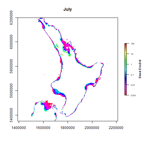
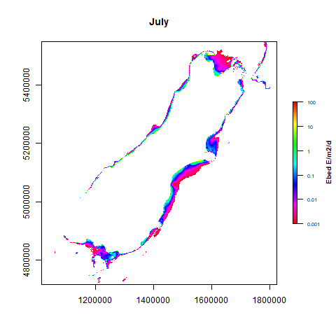
The gifs below show of the average daily light reaching the seabed for every months, estimated by satellite and for the North and South Island of New Zealand. The blue/purple colours mean almost no light whereas the green/yellow/red colours mean potentially enough light to sustain photosynthesis and productive underwater forests.
One apparent feature is the extension and retraction of the illuminated seabed, pulsing throughout the seasons. There is obviously more light reaching the seabed durign Summer than Winter. We can also see from the maps above that there is quite a bit of change in space and time of the amount of light reaching the seabed apart from the seasonal aspect. A goal of the thesis iwas to explore what is causing this variability.
June 2023
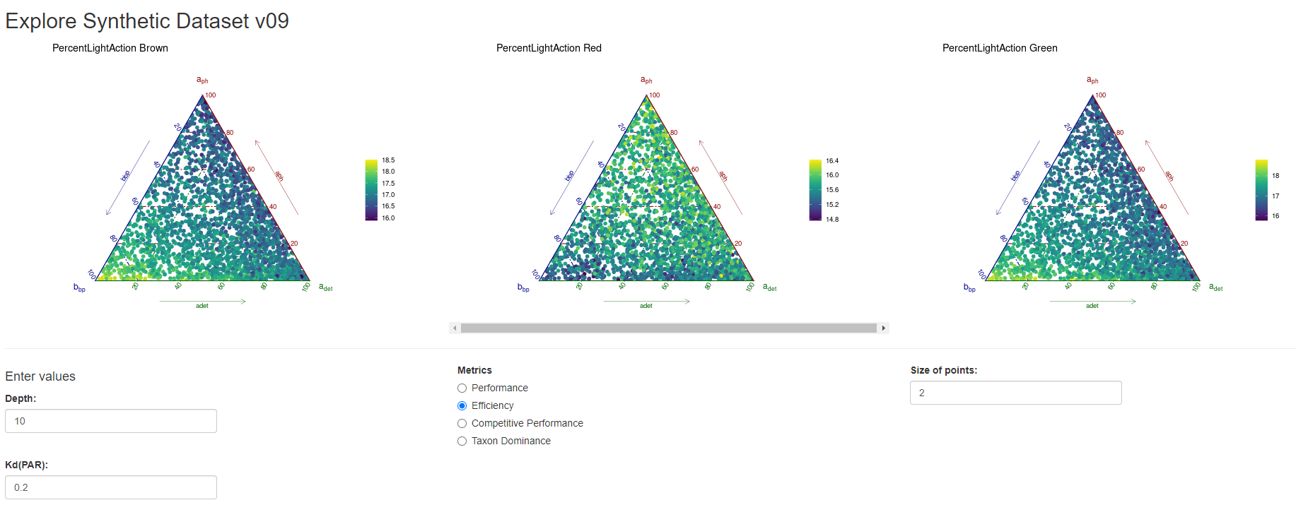
Spectral light quality on the seabed matters for macroalgal community composition at the extremities of light limitation Limnology & Oceanography
François Thoral , Matthew H Pinkerton, Leigh W Tait, David R Schiel
Compromised light quantity on the seabed affects the composition and resilience of marine forests and the maintenance of ecosystem services. However, the response of macroalgal assemblages to changes in the quality (spectral composition) of light as compared to the quantity alone is poorly understood. Here, we bridge radiative transfer modeling and algal physiology to simulate the underwater light environment and explore macroalgal responses to spectral attenuation by various coastal water constituents. We considered three groups of macroalgal taxa (class Phaeophyceae and, phyla Chlorophyta and Rhodophyta) for which we developed a “synthetic envelope” of spectrally resolved action spectra using 1 million radiative simulations. We found that brown algae were more efficient at harvesting light across the whole spectrum at low attenuation (< 0.2 m−1) when depths were greater than 10 m, whereas green algae dominated shallower depths than 10 m for low to high attenuation values. Finally, red algae made best use of the available light at relatively higher attenuation values (> 0.2 m−1) and deeper depths. We also demonstrated that the brown and green algal taxa showed higher photosynthetic efficiencies when attenuation was dominated by particulate matter rather than by phytoplankton or detrital matter. Our results shed new light on the “Complementary Chromatic Adaptation” hypothesis by confirming that algal pigmentation matters under a subset of scenarios, particularly at the limits of light availability in coastal waters. This study paves the way for identifying competitive thresholds in macroalgal communities by using satellite-derived ocean color products to identify regions and depths of potential optical transitions.
February 2023
Check out the interactive app I made for everyone to explore the dataset:
Horizon Scan on the Benefits of Ocean Seasonal Forecasting in a Future of Increasing Marine Heatwaves for Aotearoa New Zealand Frontiers in Climate
Craig L Stevens, Claire M Spillman, Erik Behrens, Niall Broekhuizen, Paula Holland, Yvonne Matthews, Ben Noll, Joanne M O'Callaghan, Neelesh Rampal, Robert O Smith, Iman Soltanzadeh, Leight W Tait, David I Taylor, François Thoral , Erica Williams
With climate heating, Aotearoa New Zealand is expected to experience more marine heatwaves (MHW) in the coming decades. These extreme events are already impacting the island nation's marine and coastal environments and marine industries at a variety of scales. There will potentially be substantial benefits in developing an early warning system–specifically ocean seasonal forecast tools. This near-term 2,030 horizon scan reviews studies supporting the development of this capability and notes work needed to enable stakeholders to benefit from this knowledge. Review findings congregate around six themes; (1) MHW impacts, (2) mechanistic understanding, (3) observational basis, (4) seasonal forecast tools, (5) supporting Te Tiriti (The Treaty of Waitangi) and Māori aspirations, and (6) end-user engagement. The primary recommendation is a cross-institutional, cross-sector MHW Taskforce that would address, in a coordinated and effective fashion, the real, multi-faceted challenges associated with the committed pathway of warming. A range of sub-recommendations follow that connect with the United Nations Ocean Decade initiative.
Matt Pinkerton, Mark Gall, Joe O'Callaghan, François Thoral , Andrew Swales
There is concern about the ecological and environmental effects of suspended sediment input in the Aotearoa New Zealand coastal marine area (CMA). This report, commissioned by the Department of Conservation as part of their “Reducing Coastal Sediment Impacts” project, provides guidance on the utility of satellite remote sensing for monitoring suspended sediment and its effects on water clarity.
May 2022
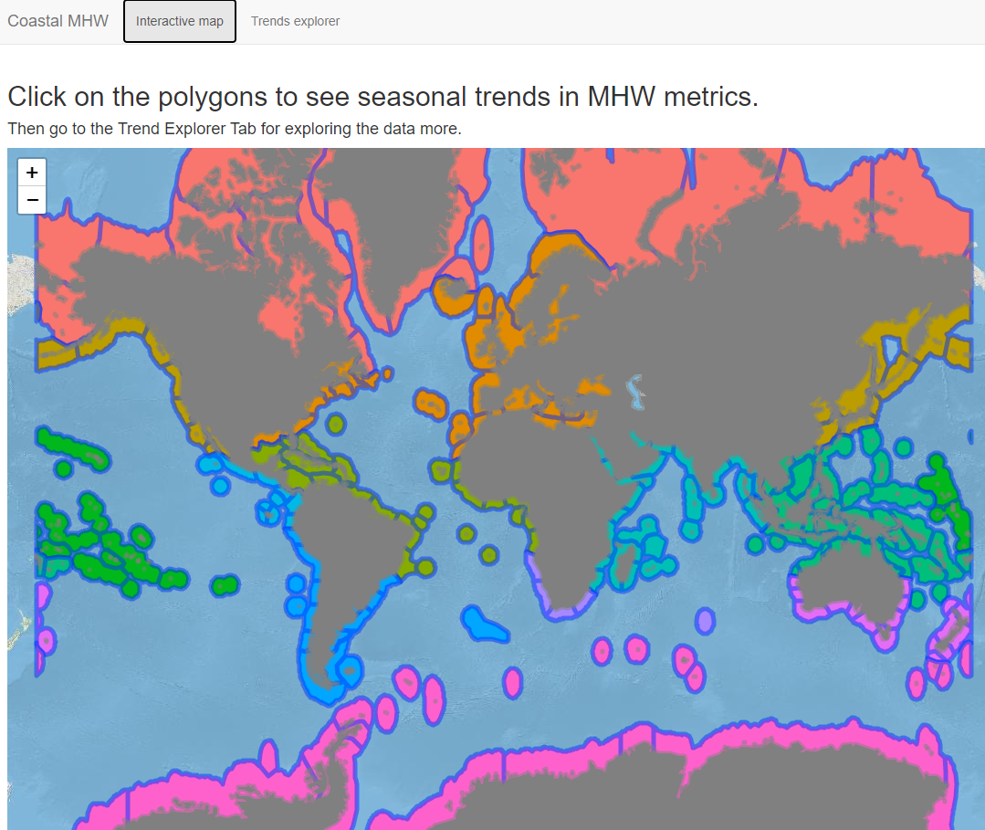
Unravelling seasonal trends in coastal marine heatwave metrics across global biogeographical realms Scientific Reports
François Thoral , Shinae Montie, Mads S Thomsen, Leigh W Tait, Matthew H Pinkerton, David R Schiel
Marine heatwaves (MHWs) can cause dramatic changes to ecologically, culturally, and economically important coastal ecosystems. To date, MHW studies have focused on geographically isolated regions or broad-scale global oceanic analyses, without considering coastal biogeographical regions and seasons. However, to understand impacts from MHWs on diverse coastal communities, a combined biogeographical-seasonal approach is necessary, because (1) bioregions reflect community-wide temperature tolerances and (2) summer or winter heatwaves likely affect communities differently. We therefore carried out season-specific Theil–Sen robust linear regressions and Pettitt change point analyses from 1982 to 2021 on the number of events, number of MHW days, mean intensity, maximum intensity, and cumulative intensity of MHWs, for each of the world’s 12 major coastal biogeographical realms. We found that 70% of 240 trend analyses increased significantly, 5% decreased and 25% were unaffected. There were clear differences between trends in metrics within biogeographical regions, and among seasons. For the significant increases, most change points occurred between 1998 and 2006. Regression slopes were generally positive across MHW metrics, seasons, and biogeographical realms as well as being highest after change point detection. Trends were highest for the Arctic, Northern Pacific, and Northern Atlantic realms in summer, and lowest for the Southern Ocean and several equatorial realms in other seasons. Our analysis highlights that future case studies should incorporate break point changes and seasonality in MHW analysis, to increase our understanding of how future,
more frequent, and stronger MHWs will affect coastal ecosystems.
May 2022
Check out the interactive app I made for everyone to explore the dataset:
Cascading impacts of earthquakes and extreme heatwaves have destroyed populations of an iconic marine foundation species Diversity and Distribution
Mads S Thomsen, Luca Mondardini, François Thoral , Derek Gerber, Shinae Montie, Paul M South, Leigh Tait, Shane Orchard, Tommaso Alestra, David R Schiel
Ecologists traditionally study how contemporary local processes, such as biological interactions and physical stressors, affect the distribution and abundance of organisms. By comparison, biogeographers study the distribution of the same organisms, but focus on historic, larger-scale processes that can cause mass mortalities, such as earthquakes. Here we document cascading effects of rare biogeographical (seismic) and more common ecological (temperature-related) processes on the distribution and abundances of coastal foundation species. Intertidal wave-exposed rocky reefs around Kaikōura, New Zealand, dominated by large, long-lived, and iconic southern bull kelps (Durvillaea antarctica and Durvillaea willana ). In November 2016, a 7.8 Mw earthquake uplifted the coastline around Kaikōura by up to 2 m, and a year later the region experienced the hottest summer on record. Extensive sampling of intertidal communities over 15 km coastline were done shortly after the earthquake and heatwaves and 4 years after the earthquake. Durvillaea lost 75% of its canopy to uplift and the heatwaves reduced canopies that had survived the uplift by an additional 35%. The survey done 4 years after the earthquake showed that Durvillaea had not recovered and that the intertidal zone in many places now was dominated by small turfs and foliose seaweed. Cascading impacts from seismic uplift and heatwaves have destroyed populations of Durvillaea around Kaikōura. Surviving smaller and sparser Durvillaea patches will likely compromise capacity for self-replacement and lower resilience to future stressors. These results are discussed in a global biogeographical-ecological context of seismic activity and extreme heatwaves and highlight that these events, which are not particularly rare in a geological context, may have common long-lasting ecological legacies.
September 2021
Loss of giant kelp, Macrocystis pyrifera, driven by marine heatwaves and exacerbated by poor water clarity in New Zealand Frontiers in Marine Science
Leigh W Tait, François Thoral , MH Pinkerton, Mads S Thomsen, David R Schiel
Marine heatwaves (MHW) are becoming stronger and more frequent across the globe. MHWs affect the thermal physiology of all biological organisms, but wider ecosystem effects are particularly impactful when large habitat-forming foundation species such as kelps are affected. Many studies on impacts from MHWs on kelps have focused on temperature effects in isolation, except for a few studies that have integrated co-occurring stress from grazers, wave exposure and nutrient limitation. It is likely that many stressors act in concert with MHWs and exacerbate their effects. Here we analyzed satellite images over 60 months to assess temporal changes in abundance of surface canopies of the giant kelp Macrocystis pyrifera in the New Zealand coastal zone. The analysis encompassed the most extreme MHW on record (2017/18), across a 6° latitudinal gradient of four regions southward from the northern distributional limit of Macrocystis along mainland New Zealand. We tested the association of surface canopy cover of Macrocystis with sea surface temperature, temperature anomalies, chlorophyll-a (a proxy for nutrient availability) and water clarity (diffuse attenuation coefficient). We found a reduced cover of Macrocystis across all regions during and after the 2017/18 MHW, with least impact at the most southern region where the maximum temperatures did not exceed 18°C. There was also an important and significant interaction between temperature and water clarity, showing that temperature-induced kelp loss was greater when water clarity was poor. These results show that notable negative effects occurred across the coastal range of this foundation species and highlight the importance of studying MHW effects across latitudinal gradients and in concert with other co-occurring stressors.
They have been introduced and defined in 2026 as sudden, unusual and intense episodes of underwater darkness that can last days to months. These events are often triggered by storms, floods, sediment plumes or algal blooms and can push marine ecosystems into acute stress.
Talks and Events
Science is amazing and a passion of me. And talking about science is crucial. I try to do my best to share my research with different audience, from scientists to the the general public. Here is a collection of my past and incoming talks.
Oral Presentation: "Marine Darkwaves": an event-based framework to assess frequency, duration and intensity of extreme periods of reduced underwater light availability
Oral Presentation: Toka Ākau Toitū Kaitiakitanga -Focusing science and Indigenous Knowledge on building a sustainable future for coastal reef ecosystems and the communities that depend on them in Aotearoa New Zealand
3-6 June 2025
International Conference on Machine Intelligence for Geoanalytics and remote sensing - MIGARS
Wellington, Aotearoa New Zealand
Scientific Presentation: Connecting land-use, sediments, and ocean color remote sensing to safeguard Aotearoa New Zealand’s coastal ecosystems health leveraging Machine Learning?
8-10 April 2024
New Zealand Marine Science Society Conference - NZMSS
Theme: “Reconnecting… people and science - Te Herenga Waka The University of Wellington, Aotearoa New Zealand
Scientific Presentation: Connecting land-use, sediment flows and macroalgal productivity around Aotearoa New Zealand’s reefs
Scientific Presentation: More or Less Light for Kelp Forests? Satellite-derived National Trends of Benthic Light and Macroalgal implications - Book of abstracts
28 October 2021
New Zealand Marine Science Society Conference - NZMSS
Theme: “Titiro whakamuri, kōkiri whakamua” (looking back to move forward) - Tauranga Moana, Aotearoa New Zealand
Scientific Presentation: National Trends of Benthic Light Availability for Kelp Forests Using Satellite Imagery
5-8 July 2021
Marine Geological and Biological Habitat Mapping Conference - GeoHab
Asia and Pacific Node - Online Conference
Scientific Presentation: Estimating Benthic Light from Satellite and Implications for Kelp Forests
Scientific Presentation: Estimating Benthic Light from Satellite and Implications for Kelp Forests - Book of abstracts
Session Chair Prize
22 October 2020
I am trying as much as I can to get involved in side projects that includes popularizing or using Science in Society. Here is a list of projects I have been fortunate to get involved into.
Ultrawild, An Audacious Plan to Rewild Every City on Earth - Steve Mushin
Written and illustrated by industrial designer, inventor and sustainability teacher Steve Mushin, Ultrawild was published by Allen and Unwin in October 2023.
Ultrawild is an illustrated science and design book about tackling climate change with hilarious engineering ideas and extreme rewilding known as ultrawilding. Ultrawild has been created in collaboration with experts ranging from climate scientists and marine biologists to mechanical engineers and soil scientists. I was very lucky to be one of them and work with Steve on some super crazy-inspiring ideas. You can find me in the book, I'll let you find where. Thanks again Steve!
National Event, NEW ZEALAND - NZ Space Agency - MBIE - MAXAR - NZ Universities
Project: Seaside Site SEALection
Our project is a coastal classification tool that automatically identifies appropriate seal habitat using very high resolution satellite imagery. The application displays an “attractiveness” score for each site on the image, which takes into consideration landscape features such as distance from cliffs and beach surface area, as well as historical presence/absence of seals at that site. The user will also add to the validity of the application by feeding in additional observation data, opening it to citizen science application.
 0000-0003-0457-1735